
Sketch of the Disposition of the Allies under the Command...


Sail: Mapak
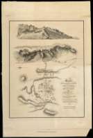
Izenburua: Sketch of the Disposition of the Allies under the Command of Lient. Genl. Hill to surprize the Enemy in Arroyo Molinos on the morning of 28th. Oct. 1811 : with Permission of the Quarter Master General
Datu-area: Escala [ca. 1:49.000]. 1 milla [=3,8 cm]
Argitalpena: [Londres?] : Published by W. Faden, Geographer to the King..., Charing Cross January 1st. 1812
Deskribapen fisikoa: 1 mapa : col. ; 31,2 x 23,7 cm en h. de 43,6 x 28,5 cm
Oharrak: Orientado con lis
Relieve representado por normales
Nota relativa a la destrucción de la división enemiga y prisioneros
Relación de la posición de los ejércitos indicados mediante clave cromática
Materia / lugar / evento: Batallas
Estratègia militar
Arroyomolinos (Cáceres)
Tokiaren izen hierarkikoa: España - Extremadura - Cáceres - Arroyomolinos de Montánchez
Otros autores: Faden, William, 1750-1836
Bigarren mailako izenburuak: CÁCERES (Provincia). Mapas generales. 1:45.000 (1811?)
CDU: 460.251 Arroyomolinos de Montánchez
Argitalpen mota:
 Mapak
Mapak
Derechos: