
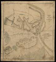
Ground of the Action near Tudela Novr. 23 d. 1808


Secció: Mapes
Títol: Ground of the Action near Tudela Novr. 23 d. 1808 / Quarter Master Genls. Office. Horse Guards. Janry. 5th. 1809
Àrea de dades: Escala [ca. 1:14.300]. 800 yardas [=5,1 cm]
Publicació: [United Kingdom] : [s.n.], 1809
Descripció física: 1 mapa : col., montado sobre tela ; 36 x 32 cm
Notes: Orientado con media flecha
Relieve representado a trazos
Relación de los ataques efectuados por las tropas francesas y españolas, así como los avances, lugares y líneas de tiro que establecieron, todo ello indicado por clave alfabética
Materia / lugar / evento: Batallas
Tudela (Navarra)
Nom jeràrquic de lloc: España - Navarra - Tudela
Otros autores: Quarter Master General Office Horse Guards
Títols secundaris: TUDELA (Navarra) (Término municipal). Estrategia militar. 1809. 1:14.300 (1808)
CDU: 912:355.43:355.4(465.111.5)"1808"
465.111.5 Tudela, Término Municipal
Tipus de publicació:
 Mapes
Mapes
Derechos: