
A New Pocket Plan of the Cities of London & Wetminster...


Sección: Mapas
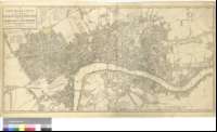
Título: A New Pocket Plan of the Cities of London & Wetminster with the Boroug of Southwark [Material cartográfico] : Comprehending the New Buildings and other Alterations to the Year 1790
Área de datos: Escala [ca. 1:9940]
Publicación: London : Printed for Willm. Faden, Geographer to the King, Charing Cross, 1790?
Descripción física: 1 plan. : col. ; 44 x 88 cm
Notas: Escala gráfica de media milla, equivalente a 800 yardas o 4 estadios [= 8,1 cm]. Orientado con lis en cuadrante
Aparece trazada una retícula que permite conocer las distancias reales entre dos puntos cualesquiera de la ciudad, al estar definidos sus ejes en intervalos de ocho estadios, equivalentes a una milla ; con respecto al meridiano de la iglesia de San Pablo
Relación de los distritos de Westminster, indicados por clave alfabética ; así como de las parroquias de Liberties, mediante clave numérica
Forma parte de la Colección Mendoza
Materia / lugar / evento: Inglaterra
Westminster (Londres, Municipio)
Southwark (Londres, Municipio)
Gran Londres
Otros autores: Faden, William, 1750-1836
Títulos secundarios: LONDRES (Reino Unido). Planos de población. 1:9940 (1790?)
CDU: 912:[314(084.3)]+(1-2/-5)(420-250)"1790"
420 Londres
420 Westminster
420 Southwark, barrio
Tipo de publicación:
 Mapas
Mapas
Derechos: