
[Map of the New Forest]


Secció: Mapes
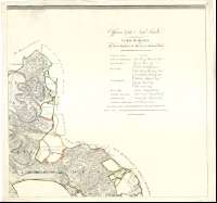
Títol: [Map of the New Forest] [Material cartográfico] / W. Faden
Autor: Faden, William, 1750-1836
Àrea de dades: Escala [ca. 1:16100]
Publicació: [London] : engraved & Published by W. Faden, Geographer to the King, 1789
Descripció física: 1 map. en 9 h. : col. ; 162 x 168 cm, en h. de 58 x 61 cm
Notes: Título redactado a partir del contenido del documento
Escala gráfica de 2 millas estatutarias o 16 estadios [= 20 cm]. Orientado con lis en rosa de dieciséis vientos
Orografía a trazos
Figura una tabla con datos referentes a la extensión de los alguacilazgos
Clave cromática para indicar los distintos tipos de finca : bosques abiertos, terrenos arrendados por la corona, propiedades con intermediario, etc.
Consta una lista con los nombres de los oficiales destinados en New Forest
Todas las hojas aparecen numeradas en su ángulo superior derecho
Forma parte de la Colección Mendoza
Inserta : "An Indec Map of New Forest, shewing the Connection of the respective sheets in the large surrey". Escala [ca. 1:48300], 3 millas [= 10 cm]
Materia / lugar / evento: Inglaterra - Divisiones territoriales - S. XVIII - Mapas
New Forest National Park - S. XVIII - Mapas
Género / forma: Mapas administrativos
Nom jeràrquic de lloc: Gran Bretaña - Inglaterra
Títols secundaris: NEW FOREST (Reino Unido). Inglaterra. Fincas rústicas. 1789. 1:16100
CDU: 912:333.5+[912(083.86)](420)"1789"
420 New Forest
Tipus de publicació:
 Mapes
Mapes
Derechos: