
A plan of Manchester and Salford


Secció: Planos
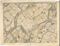
Títol: A plan of Manchester and Salford [Material cartográfico] / Drawn from an actual survey by William Green, Begun in the year 1787 and Compleated in 1794 ; engraved by J. Thornton ; W. Thomas sculpt
Autor: Green, William
Área de datos: Escala [ca. 1:2200]
Publicació: Manchester : Published by W. Green, April 1, 1794
Descripció física: 1 plan. en 9 h. ; 144 x 173 cm, h. de 53 x 69 cm y 54 x 51 cm
Notes: Comprende los planos de las ciudades mencionadas y sus alrededores, habiendo sido englobada en la actualidad Salford por Manchester
Escala gráfica de 440 yardas o 1/4 de milla [= 18,8 cm]. Orientado con lis en cuadrante de orientación
Orografía a trazos
Toponimia de las principales calles y plazas de la ciudad, así como de sus edificios más representativos
Localiza las haciendas de los alrededores, indicando los hombres de sus propietarios
Título enmarcado en escena alegórica sobre la riqueza de Manchester (Fortuna derramando monedas sobre tres puttique le presenta el plano de la misma, figurándo al fondo el edificio de una fábrica)
Forma parte de la Colección Mendoza
Materia / lugar / evento: Planos de población - S. XVIII - Mapas
Manchester - S. XVIII - Mapas
Salford - S. XVIII - Mapas
Otros autores: Thornton, John, s. XVIII
Thomas, W.
Títulos secundarios: MANCHESTER (Reino Unido). Planos de población. 1:2200 (1794)
CDU: 912:[314(084.3)]+333.5+(1-2/-5)(420)"1794"
420
Tipus de publicació:
 Mapes
Mapes
Derechos: