
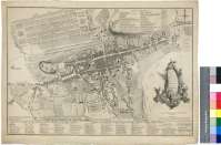
General plan of the City, Castle and Suburbs of Edinburgh


Secció: Mapes
Títol: General plan of the City, Castle and Suburbs of Edinburgh [Material cartográfico] / Engraved by W. Faden successor to the late T. Jefferys Geogr. to the King
Autor: Faden, William, 1750-1836
Área de datos: Escala [ca. 1:5400]
Publicació: London : Publishd according to Act of Parliament... by Faden and Jefferys Corner of St. Martins Lane Charing Cross, November 12 th. 1773
Descripció física: 1 plan. ; 34 x 49 cm
Notes: Escala gráfica de 2 estadios o 1320 pies [= 7,4 cm]. Orientado con lis en rosa de ocho vientos
Orografía a trazos
Toponimia de las principales calales y plazas de la ciudad
Relación de los edificios públicos más significativos de la capital escocesa indicados por calve alfabética, y de los edificios "abiertos" y "cerrados" de High Street, por clave numérica
Título enmarcado en cartela barroca
Forma parte de la Colección Mendoza
Materia / lugar / evento: Edimburgo - S. XVIII - Planos
Género / forma: Planos de población
Nom jeràrquic de lloc: Gran Bretaña - Edimburgo
Otros autores: Jefferys, Thomas, ca. 1710-1771
Títulos secundarios: EDIMBURGO (Reino Unido) (Escocia). Planos de población. 1:5400 (1773)
CDU: 912:[314(084.3)]:725.1(411)"1773"
411 Edimburgo
Tipus de publicació:
 Mapes
Mapes
Derechos: