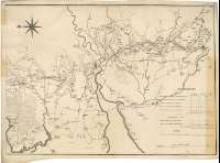
Plan of the Proposed Lancaster Canal from Kirby Kendal in...
Secció: Planos
Títol: Plan of the Proposed Lancaster Canal from Kirby Kendal in the County of Westmorland to West Houghton in the County Palatine of Lancaster [Material cartográfico]surveyed in the Years 1791 & 1792 / By John Rennie, Engineer F.R.S.E
Autor: Rennie, John, (1761-1821
Área de datos: Escala [ca. 1:65700]
Publicació: [s. l.] : Engraved by W. Faden, Geogr. to the King, 1792
Descripció física: 1 map. en 2 h. ; 51 x 142 cm, en h. de 53 x 74 cm
Notes: Comprende parte de los condados ingleses de Lancashire y Cumbria
Escala gráfica de 6 millas estatutarias [= 14,7 cm]. Orientado con lis en rosa de ocho vientos
Orografía a trazos
Figuran tres tablas referentes a las dimensiones y capacidad de los tramos de la obra proyectada
Forma parte de la Colección Mendoza
Materia / lugar / evento: Inglaterra - S. XVIII - Mapas
Inglaterra - Canales - Mapas
Cumbria - Canales - S. XVIII - Mapas
Lancashire - Canales - S. XVIII - Mapas
Canal de Lancaster - S. XVIII - Proyectos
Nom jeràrquic de lloc: Gran Bretaña - Inglaterra
Otros autores: Faden, William, 1750-1836
Títulos secundarios: LANCASHIRE (Reino Unido) (Inglaterra). Canales. 1792. 1:65700 (1791-1792)
CDU: 912:626.13(083.9(](420)"1791/1792"
429 Lancaster, canal
420 Lanashire, condado
420 Cumbria, condado
Tipus de publicació:
![]() Mapes
Mapes
Derechos: CC BY. Esta licencia permite utilizar las obras siempre que se mencione la fuente de procedencia
© Ministeri de Cultura


