
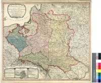
A Map of the Kingdom of Poland and of the Grand Dutchy of...


Secció: Mapes
Títol: A Map of the Kingdom of Poland and of the Grand Dutchy of Lithuania with their Dismembered Provinces and the Kingdom of Prussia [Mapa] / By Willm. Fadem, Geographer to The King
Autor: Faden, William, 1750-1836
Área de datos: Escala [ca. 1:2370000]
Publicació: London : Published by W. Fadem, Charing Cross, Feb. 1th. 1792
Descripció física: 1 map. : col. ; 53 x 59 cm
Notes: Comprende las actuales Polonia, la provincia de Kaliningrandskaya OBlast, Lituania, Letonia, Bielorusia, Ucrania y parte de la URSS hasta Orel
Escalas gráficas de 24 millas comunes de Polonia y Alemania de 15 al grado [= 7,5 cm] ; 35 millas de Lituania y Prusia de 20 al grado [= 8,2 cm] y 100 millas inglesas de 69 1/2 al grado [= 6,6 cm]. Coordenadas referidas al meridiano de Londres (E 16°12'--E 34°22'/N 57°21'--N 46°30')
Orografía de perfil
Territorios y límites diferenciados por color
Leyenda relativa a los trabajos en que se han basado para la elaboración de este mapa
Consta una estadística demográfica de esos territorios
Dos cartelas enmarcando los datos e inserta del mapa, una de ellas en forma de tríptico, decoradas con motivos vegetales
Forma parte de la Colección Mendoza
Inserta: "Warszawa = Warsaw"
Materia / lugar / evento: Mapas generales
Planos de población
Divisiones administrativas
Varsovia (Polonia)
Lituania
Bielorrusia
Ucrania
Kaliningrandskaya Oblast' (URSS) (RSFS de Rusia) (Provincia)
RSFS de Rusia (URSS)
Otros autores: Faden, William, 1750-1836
Títulos secundarios: POLONIA. Mapas generales. 1792. 1:2370000
CDU: 912(1-2/-5)/(476)(477-15)(474.5)(470.1)(438)"1792"
476
474.5
470.1 Kaliningradskaya Oblast'
438
477-15
Tipus de publicació:
 Mapes
Mapes
Derechos: