
Wallis's New and Corret Map of the Post Roads of England...


Secció: Mapes
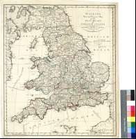
Títol: Wallis's New and Corret Map of the Post Roads of England & Wales [Mapa]
Área de datos: Escala [ca. 1:1400000]
Publicación, Producción, Distribución, etc.: Publicación: London : Published by John Wallis, at his Map Warehouse, No. 16, Ludgote Street, Augt. 2nd. 1790
Descripció física: 1 map. : col. ; 55 x 47 cm
Notes: Comprende además una pequeña parte del sur de Escocia y de Irlanda oriental
Escala gráfica de 60 millas inglesas, habiéndose tomado para su cálculo las estatutarias [= 6,9 cm]. Coordenadas referidas al meridiano de Londres (O 6°30'--E 2°00'/N 56°00'--N 49°22'). Red geográfica de 5° en 5°
Señala bajos
Representa los caminos de posta con indicación de las distancias entre distintos puntos
Determina las líneas de derrota que parten de distintos puertos de Inglaterra y Reino Unido hacia otroa puntos del continente o de las islas con indicación de las distancias en leguas y, en algunos casos, los días de salida
Límites administrativos entre los condados diferénciados por colores
Forma parte de la Colección Mendoza
Materia / lugar / evento: Mapas generales
Correos
Transporte marítimo
Derroteros
Gales
Otros autores: Wallis, J.
Títulos secundarios: INGLATERRA (Reino Unido). Mapas generales. 1:1400000 (1790)
CDU: 912:656.8:656.61:527.6:(1-35)(420)(429)"1790"
420
429
Tipus de publicació:
 Mapes
Mapes
Derechos: