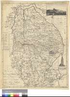
The Map of Lincoln-Shire : Reduced from the Actual Survey...
Secció: Mapes
Títol: The Map of Lincoln-Shire : Reduced from the Actual Survey made in the Years 1776, 7 & 8 and Published Jany 20 1779 on Eight Sheets, By Capt. Andrew Armstrog ; J. Thompson sculp [Mapa]
Autor: Armstrong, Andrew
Área de datos: Escala [ca. 1:205000] (O 1°05'--E 0°25'/N 53°50'--N 52°38')
Publicació: London : Published by R. Sayer, Printseller, N°53 Fleet Street, 1787
Descripció física: 1 map. : col. ; 65 x 50 cm
Notes: Escala hallada a partir de un minuto de latitud [= 0,9 cm]. Orientado con lis en nudo de dieciseis rumbos. Recuadro geográfico de 1' en 1'
Señala especialmente los caminos
Distingue, mediante colores, los límites entre distintas divisiones del condado
En el margen izquierdo una tabla ofrece la distancia en millas desde Lincoln a las principales poblaciones del condado
Inserta : " South East View of the City of Lincoln". "Boston Church"
Materia / lugar / evento: Mapas generales
Divisiones administrativas
Caminos
Inglaterra
Otros autores: Thompson, J.
Sayer, Robert, 1725-1794
Títulos secundarios: LINCOLNSHIRE (Reino Unido). Inglaterra. Condado. Mapas generales. 1787. 1:205000 (1776-1778)
CDU: 912:625.7:(1-28)(420)"1776/1778"
420 Lincolnshire, condado
Tipus de publicació:
![]() Mapes
Mapes
Derechos: CC BY. Esta licencia permite utilizar las obras siempre que se mencione la fuente de procedencia
© Ministeri de Cultura


