
A Compleat and Exact Map of the Lothians : Containing the...


Secció: Mapes
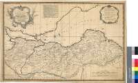
Títol: A Compleat and Exact Map of the Lothians : Containing the Shires of Edinburgh, Handdington and Linlithgow ; with a View of the Country from Stirlingshire to Berwickshire : In wich is mark'd out the different Marches of the Rebels & their Encanmpmts. in these Countries : Being the fullest & most particular of any Map yet Extant [Mapa] / Surveye'd by Mr. Adair with some Improvents. by a Gentlman ; T. Kitchin Sculp. 1745
Autor: Adair, John, 1660-ca. 1718
Área de datos: Escala [ca. 1:1350000]
Publicació: London : Printed for A. Millar opposite Katherine Street in the Strand..., according to Act of parliamt., Novr. 1745
Descripció física: 1 map. : col. ; 42 x 65 cm
Notes: Dedicatoria "To the Right Honble. John Earl of Stair Field Marshal & Commander in Chief of his Majesty's Forces in South Britain & C. This Map of the Lothians, shewing the March of the Rebels & Battle of Prestan Is inscribd by your Lordshps. most Obliged & most Obedt. Humble Servt. And. Miller"
Escalas gráficas de 10 millas comunes escocesas de 60 al grado, 12 millas de 72 al grado y 8 millas escocesas de 48 al grado [= 13,8 cm]. Coordenadas referidas al meridiano de Edimburgo (O 0°34'--E 0°47'/n 56°13'--N 55°43'). Red geográfica de 5' en 5'. Orientado con lis en rosa de treinta y dos vientos
Orografía por perfil. Veriles, bajos y bancos de arena
Clave alfabética para indicar la posición de los componentes rebeldes y leales
Límites entre los distintos condados diferenciados por colores
Título y dedicatoria enmarcados en sendas cartelas barrocas
Materia / lugar / evento: Mapas generales
Divisiones administrativas
Campamentos militares
Escocia
Otros autores: Kitchin, Thomas, 1718-1784
Millar, Andrew, 1707-1768
Títulos secundarios: LOTHIAN (Reino Unido). Escocia. Región. Mapas generales. 1745. 1:135000
CDU: 912:355.71(411-37)"1745"
411 Lothian, Región
Tipus de publicació:
 Mapes
Mapes
Derechos: