
The Atlantic Neptune


Secció: Mapes
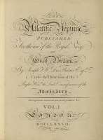
Títol: The Atlantic Neptune [Material cartográfico] / published for the use of the Royal Navy of Great Britain by JosephF.W. Des Barres Esqr under the directions of the Righ Houble. The lords Commisioners of the Admiralty
Área de datos: Escalas diferentes
Publicació: London : Joseph F.W. Des Barres, 1777- 1780
Descripció física: 1 atlas (2 v.(I, 70h : II, 49h ; 66 map. , 57 x 43 cm
Notes: Presenta la batimetría de sondas y calidad del fondo de diversos puertos, bahías y desembocaduras de ríos de Nueva Inglaterra y de Nueva Escocia
Los documentos graduados, en su mayor parte, toman la longitud respecto del meridiano de Greenwich
Escalas gráficas expresadas en millas legales y en millas náuticas
Orientado con lis
Volúmenes encuadernados, apareciendo en ambos lomos la siguiente leyenda : "Atlas maritime anglais", vol. I, tomo 16 y vol II, tomo 17, siendo desconocido el origen de dicha encuadernación. Vol 1 "The sea coast of Nova Scotia; exhibiting the diversities of the coast and face of the country near it : the banks, rocks, shoals, soundings, etc. together with remarks and directions for the conveniency of navigation and pilotage --Vol. 2 "Charts of the coast and harbours of New England from surveystaken Saml. Holland Esqr. survr. Genrl. of lands for the northern district of North America and Geoe. Sproule. Chas. Blascowitz
Copia digital. Madrid : Ministerio de Cultura. Dirección General del Libro, Archivos y Bibliotecas, 2010
Materia / lugar / evento: Nueva Escocia (Canadá) - Costas - Cartas náuticas
Nueva Inglaterra (Estados Unidos) - Costas - Cartas náuticas
Nom jeràrquic de lloc: Estados Unidos
Canadá
Títulos secundarios: NUEVA INGLATERRA (Estados Unidos). Región. Cartas náuticas. 1778
CDU: 912:551.468]:742]:627.22:551.42+556.54(73-18)(716)"17"(084.4)
73-18
716
Tipus de publicació:
 Mapes
Mapes
Derechos: