
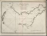
Bay and River of Pontevedra


Secció: Mapes
Títol: Bay and River of Pontevedra [Material cartográfico] / Surveyed by Brigadier Don Vincent Tofiño
Área de datos: Escala ^ca. 1:56.306!. 3 Maritim Miles ^=7,4 cm!
Publicació: London : Published by W. Faden, geographer to His Majesty, and to His Royal Highness the Prince Regent, 1812
Descripció física: 1 mapa ; 27 x 35 cm
Materia / lugar / evento: Pontevedra (España, Bahía)
Género / forma: Cartas náuticas
Nom jeràrquic de lloc: España - Galicia - Pontevedra - Pontevedra
Otros autores: Faden, William, 1750-1836
Dougall, John, 1760-1822, trad.
Títulos secundarios: Pontevedra (Ría). Cartas náuticas. 1:56.306 (1812)
CDU: 460
Tipus de publicació:
 Mapes
Mapes
Derechos:
Museu Naval
Signatura: MN_A_10020_15