
A New and Correct Chart of the Sea Coast from Borkumer...


Secció: Mapes
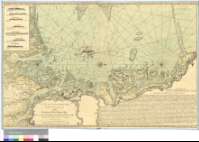
Títol: A New and Correct Chart of the Sea Coast from Borkumer Riff to Dehorn Riff [Material cartográfico] : shewing the Sands, Sheels, and Depths of Water with the Setting of the Tides from an Accurate Survey
Área de datos: Escala [ca. 1:330000]
Publicació: on Tower Hill [London] : Sold by I. Mount and T. Page, [1764-1773?]
Descripció física: 1 map. : col., montado sobre tela ; 56 x 88 cm
Notes: Carta arrumbada que comprende la parte occidental de la costa de la República Federal Alemana y la suroccidental de Dinamarca, hasta la actual ciudad de Orksby
Fecha tomada del "Tooley's Dictionary of Mapmarkers", Tring, 1979, p. 451
Escalas gráficas de 6 millas alemanas de 15 al grado y 8 leguas inglesas y francesas de 20 al grado [= 13,5 cm]. Graduado únicamente en latitud (N 55°39'--N 53°07'). Orientado con lis en rosa de treinta y dos vientos
Orografía de perfil
Indica sondas batimétricas, fondeaderos, bajos, bancos, dirección de las corrientes y enfilaciones
Leyenda explicativa sobre la navegación en esta costa
Título, pie de imprenta, escalas y leyenda enamarcados en doble cartela rococó
Forma parte de la Colección Mendoza
Inserta : "The Different Appearances of the Land as seen out at Sea"
Materia / lugar / evento: Toponimia
Perspectivas de costas
Alemania - S. XVIII - Mapas
Dinamarca - S. XVIII - Mapas
Género / forma: Cartas náuticas
Otros autores: Jno. Mount and Tho. Page
Títulos secundarios: Alemania. Occidental. Costa. Cartas náuticas. 1764-1773?. 1:330000
CDU: 912:551.468]:742+[801.311](430.1-15)(489-14)"1764/1773"
430.1-15
489-14
Tipus de publicació:
 Mapes
Mapes
Derechos: