
Plan of the Antient Town and Borough of Colchester in the...


Secció: Planos
Títol: Plan of the Antient Town and Borough of Colchester in the County of Essex [Material cartográfico] / Thos, Sparrow, Land Surveyor in Hammersmith, Middelexm Survey'd & Delind.
Autor: Sparrow, Thos, fl. ca. 1767
Área de datos: Escala [ca. 1:4000]
Publicació: [United Kingdom : W. Keymer], 1767
Descripció física: 1 plan. ; 51 x 71 cm
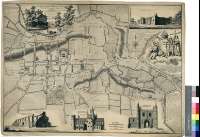
Notes: Dedicatoria : "To the Society of Antiquary's in London, this Actual Survey of the Antien Town and Borough of Colchester in the County of Essex, is most Humbly Dedicated by their Obedient Servant Thos. Sparrow, Land Surveyor in Hammersmith Middelesex, Survey'd & Delind. 1767"
Título y mención de responsabilidad tomados de la dedicatoria
Nombre del editor tomado de : "Tooley's Dictionary of Mapmakers", Tring, 1979, p. 353
Escalas gráficas de 10 chains [= 5 cm], 600 pies [= 4,5 cm] y 100 pasos [= 2,3 cm]. Orientado con lis en rosa de dieciseis vientos prolongados
Orografía a trazos
Toponimia de calles y plazas
Leyenda explicativa sobre la situación, historia, ferias y mercados de Colchester
Notas explicativas sobre la inclusión en el mapa de los jardines, cercas, etc, y sobre el descubrimiento de antigüedades romanas en la ciudad
Dedicatoria enmarcada en paisaje rural (molino a orillas de un río junto al cual trabajan varios campesinos). Escudo de la ciudad apoyado en león y flanqueado por figura mitológica y Santa Elena sosteniendo la cruz y bajo el cual una leyenda explicativa informa del nacimiento de la santa en la ciudad
Forma parte de la Colección Mendoza
Inserta los alzados de cuatro edificios : "The N.W. Prospect of the Ruins of St. Botolph's Priory Church". "The South Prospect of St. John's Abbey Church". "The North East Prospect of the Castle". Nota explicativa sobre su historia. "The North Front of St. John's Abbey Gate"
Materia / lugar / evento: Planos de población
Edificios
Alzados
Essex (Reino Unido) (Condado) - S. XVIII - Mapas
Otros autores: Keymer, W.
Títulos secundarios: COLCHESTER (Reino Unido) (Inglaterra). Planos de población. 1767. 1:4000 (1767)
CDU: 912:[314(084.3)':721:744.4(420)"1767"
429 Colchester
Tipus de publicació:
 Mapes
Mapes
Derechos: