
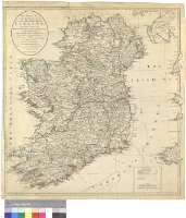
Bowles's New Pocket Map of the Kingdom of Irland, divided...


Secció: Mapes
Títol: Bowles's New Pocket Map of the Kingdom of Irland, divided into it's Provinces, Counties & Baronies : comprehending all the Cities, Boroughs, Market and Post Towns, Barracks and Principal Villages with The Great, the Branch, and the Bye Post Roads, and Distances thereon, from the best Authorities [Mapa]
Área de datos: Escala [ca. 1:820000]
Publicació: London : Printed for the Propietor Carington Bowles, No. 69 in St. Pauls Church Yard... Published as the Act directs, 24 June 1791
Descripció física: 1 map. : col. ; 62 x 59 cm
Notes: Comprende Irlanda e Irlanda del Norte
Escala gráficas de 30 millas estatutarias inglesas de 69 1/2 al grado [= 5,9 cm] y 30 millas irlandesas [= 7'6 cm]. Coordenadas referidas al meridiano de Londres (O 11°20'--O 4°24'/N 55°24'--N 51°04'). Red geográfica de 1° en 1°. Orientado con lis en rosa de cuatro vientos
Orografía de perfil. Indica bajos y bancos
Límites entre los condados diferenciados por colores
Traza varias líneas de derrota desde Irlanda hasta puertos de Escocia, Inglaterra y Gales, dando cuenta de la distancia en millas
Tabla de signos convencionales para indicar distintos tipos de poblaciones y carreteras
Forma parte de la Colección Mendoza
Materia / lugar / evento: Mapas generales
Divisiones administrativas
Transporte marítimo
Derroteros
Irlanda del Norte (Reino Unido)
Otros autores: Bowles, Carrington
Títulos secundarios: IRLANDA. Mapas generales. 1:820000 (1791)
CDU: 912:656.61:527.6:(1-35)(416/417)"1791"
416
417
Tipus de publicació:
 Mapes
Mapes
Derechos: