
A New Chart of Holland with the Entrances to the Scheld, &c


Secció: Mapes
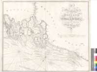
Títol: A New Chart of Holland with the Entrances to the Scheld, &c [Mapa] / Drawn from the lalest Authorities, by W. Heather ; Engraved by J. Stephenson
Autor: Heather, William, 1764-1812
Área de datos: Escala [ca. 1:94000]
Publicació: London : Published as the Act directs... by Wm. Heather, at the Navigation Warehouse, No. 157, Leadenhall Street, November 5th, 1802
Descripció física: 1 map. ; 63 x 77 cm
Notes: Carta arrumbada que comprende la costa suroccidental de los Países Bajos desde Rotterdam, la costa de Bélgica y una pequeña parte de la noroccidental de Francia hasta Calais
Escalas gráficas de 13 millas inglesas y francesas de 60 al grado [= 25'5 cm] y 9 millas danesas y alemanas de 15 al grado [= 23'9 cm]. Orientado con media lis en uno de los nudos de treinta y dos rumbos, en el que se señala además la variación magnética observada
Orografía de perfil
Indica sondas batimétricas, fondeaderos, enfilaciones, bancos y dirección de las corrientes ; así como los faros existentes, destacados en rojo con posterioridad a la elaboración del documento
Está incluído en un grupo de mapas dispuestos a modo de cuaderno : "North Sea" ; "The entrances to the River Thames" ; "East Coast of England" ; "East Coast of England and Scotland" ; "The Coast of Holland and England" ; "A New and Improved Chart of the Rivers Elbe and Weser to Hamburg and Bremen"
Forma parte de la Colección Mendoza
Títulos secundarios: PAISES BAJOS. Costa suroccidental. Cartas náuticas. 1802. 1:94000
CDU: 912:551.46]+[801.311](482-14)(493)"1802"
492-14
493
Tipus de publicació:
 Mapes
Mapes
Derechos: