
A Plan of the County of Mid-lo-thian or Shire of...


Secció: Planos
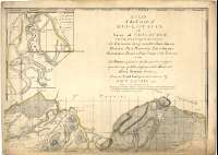
Títol: A Plan of the County of Mid-lo-thian or Shire of Edinburgh : delineating in a particular manner, the Boundaries thereof, and all the Roads Rivers, Rivolets, Hills, Plantations, Towns, Villages, Gentlemen's houses, & Farm Steads in the County : Also the Height, in feet, above the sea, put down in figures upon the Tops of all the most remarkable Hills and Rising Grounds therein [Mapa] / From an Actual Survey made & drawn by John Laurie 1793 ; Alexr. Baillie sculpsit
Autor: Laurie, John
Área de datos: Escala [ca. 1:32500]
Publicació: [United Kingdom?] : s.n.] Published according to Act of Parliament, 1763
Descripció física: 1 map. en 4 h. : col. ; 104 x 143 cm en hoja de 55 x 76 cm
Notes: Dedicatoria : "To The Right Honourable Charles Earl of Elgin and Kincardine, Most Worshipful Grand Master Marson of Scottland ; The Grand Lodge thereof, And all the Members of the Most Antient and honourable Society of Free & Accepted Masons Therein"
Escala gráfica de 2 millas estatutarias [= 9'9 cm]. Coordenadas referidas al meridiano de Edimburgo (O 0°24'--E 0°21'/N 55°59'--N 55°41'). Red geográfica de 1' en 1'. Orientado lis en rosa de ocho vientos y círculo con mención nominal de los puntos cardinales
Orografía por normales y puntos acotados
Nota referente a la utilización, para otros mapas, de los puntos acotados en éste indicados, al ser la primera vez que el relieve era representado mediante este método (1745)
Dedicatoria enmarcada en cartela rococó
Inserta : "Southmost Point of the Country : Scale and situation the same with the general Plan. Coordenadas referidas al meridiano de Edimburgo (E 0°22'--E 0°15'/N 55°44'--N 55°39°) ; Punto más occidental del condado. Escala [ca. 1:32500]. Coordenadas referidas al meridiano de Edimburgo (O 0°24'/N 55°51'--N 55°48')
Materia / lugar / evento: Mapas generales
Escocia
Otros autores: Laurie, John
Baillie, Alex, fl. 1774
Títulos secundarios: LOTHIAN (Reino Unido). Escocia. Región. Mapas generales. 1763. 1:32500
CDU: 912(411)"1763"
411 Lothian, región
Tipus de publicació:
 Mapes
Mapes
Derechos: