
To the Right Honourable Francis Earl of Huntingdon Bacon,...


Secció: Mapes
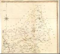
Títol: To the Right Honourable Francis Earl of Huntingdon Bacon, Hastings, Hungerford, Nenmark, Peverel, Botreaux, Molins, Moels and the Homet By His Lordfships Permission This Map of Leicestershire [Mapa] / from and actual Survey, Begun in the Year 1775, and finished in the Year. 1777. With the almost Gratitude and Respect is dedicated, by His Lordships most obliged most obedient and most humble servant John Prior ; Engrav'd by J. Luffman No.98 Newgate Street, London
Autor: Prior, John
Edición: Luffman No 98 Newgate Street, London
Área de datos: Escala [ca.1:65500]
Publicació: London : Publish'd according to Act... and sold by Willm. Dawson. - Leicester : J. Gregory. - Ashby-de-la-Zouch : Publish'd according to Act... and sold by Willm. Danson No.7, Pater-noster, Row, 1st. Jany. 1779
Descripció física: 1 map. en 4 h. : col. ; 112 x 121 cm, en h. de 61 x 64 cm
Notes: Escalas gráficas de 6 millas estatutarias [= 14,7 cm], y 5 millas geográficas [=14,2 cm]. Coordenadas referidas al parecer, al meridiano de Londres O 0°07'00''--O 0°02'30''/N 52°59'00''--N 52°21'30'') Se hace referencia la latitud de la iglesia de San Martín en Leicester y se cita la diferencia entre el meridiano de Leicester y el Observatorio de Greenwich siendo esta de 4'35'' O. Recuadro geográfico de 5' en 5'. Orientado con lis en rosa de ocho vientos prolongados
Destaca especialmente las divisiones administrativas
Tablas de signos convencionales para indicar núcleos de población, molinos de viento, caminos, etc.
Leyenda explicativa sobre las observaciones astronómicas realizadas
Título enmarcado en cartela barroca decorada con motivos vegetales y ruinas, y coronada por el escudo real, flanqueado por leones
Inserta :"A plan of Leicester". Escala [ca.1:6100], 500 y ardas [= 7,5 cm]. Relación de los principales edificios indicados por clave alfabética ; "This Diagram is inserted to shew principal stations in this Survey, from whence all other places are projected. inteaded for the use of the Curious,and for a testimony of the Accuracy of this work"
Materia / lugar / evento: Planos de población
Mapas generales
Divisiones administrativas
Leicester (Reino Unido) (Inglaterra) (Ciudad)
Inglaterra
Otros autores: Dawson, William
Gregory. J.
Luffman, John, fl. 1776-1820
Títulos secundarios: LEICESTERSHIRE (Reino Unido) (Inglaterra). Mapas generales. 1779. 1:65500 (1775-1777)
CDU: 912.(1-28)+[314(084.3)](420)"1775/1777"
420 Leicestershire, condado
Tipus de publicació:
 Mapes
Mapes
Derechos: