
A New and General Map of the Middle Dominions Belonging...


Secció: Mapes
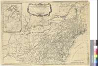
Títol: A New and General Map of the Middle Dominions Belonging to the United States of América : viz Virginia, Maryland, the Delaware-Counties, Pennsylvania, New Jersey, etc. with the Addition of New York, and of the Greatest Part of New England, etc. as also of the Bordering of the British Possessions in Canadá
Área de datos: Escala [ca. 1:2000000 ; proyec. cónica]
Publicació: London : Robert Sayer, 1788
Descripció física: 1 mapa ; 49 x 67 cm
Notes: Presenta además un mapa de parte de los Grandes Lagos
Escala gráfica de 130 millas británicas de 69 y medio al grado [= 10,1 cm]. Coordenadas referidas al meridiano de Londres (O 85º25'-O 71º50'/N 46º45'-N 36º25'). Red geográfica de 1º en 1º
Relieve de perfil
Título en cartela orlada
Materia / lugar / evento: Mapas generales
Relaciones exteriores
Fronteras
Otros autores: Sayer, Robert, 1725-1794
Títulos secundarios: Estados Unidos. Mapas generales. 1:2000000 (1788)
CDU: 73-11
Tipus de publicació:
 Mapes
Mapes
Derechos: