
Harbour of Cadiz


Section: Maps
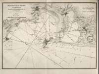
Title: Harbour of Cadiz [Material cartográfico] / Surveyed by Brigr. Don Vincent Tofiño
Área de datos: Escala ca. 1:61.274!. 3 Maritime Miles = 6,8 cm!
Publication: London : Published by W. Faden, Geographer to His Majesty, and to His Royal Highness the Prince Regent, 1812
Physical description: 1 mapa ; 27 x 35 cm
Materia / lugar / evento: Puerto de Cádiz - S. XIX
Cádiz
Género / forma: Cartas náuticas
Hierarchical place name: España - Andalucía - Cádiz - Cádiz
Otros autores: Faden, William, 1750-1836
Dougall, John, 1760-1822, trad.
Títulos secundarios: Cádiz (Bahía). Cartas náuticas. 1:61.274 (1812)
UDC: 460
Type of publication:
 Maps
Maps
Derechos:
Naval Museum
Signature: MN_A_10022_20