
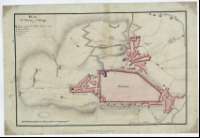
Plan de L'Attaque d'Astorga


Section: Planos
Title: Plan de L'Attaque d'Astorga
Área de datos: Escala [ca. 1:6.000]. 300 toesas [=9,7 cm]
Publication: [S.l.] : [s.n.], [1810]
Physical description: 1 plano : ms., col., montado sobre tela ; 28,5 x 42 cm
Notes: Comprende el recinto de la ciudad y el plano de sus arrabales localizando las posiciones de las baterías y piezas de artillería del ejército atacante, mostrando el plan de fuego de éstas últimas
Fecha tomada del catálogo del SGE: "Provincias de León, Zamora y Salamanca. Siglos XVIII-XIX". 1967. P. 311
Orientado con flecha
Relieve representado a trazos
Manuscrito coloreado a la acuarela en azul, siena y carmín
Relación de los principales lugares y edificios donde se desarrolló el ataque y los ocupados tras él, indicada por clave alfabética
Materia / lugar / evento: Estratègia militar
Astorga
Hierarchical place name: España - Castilla y León - León - Astorga
Títulos secundarios: ASTORGA (León). Asedios. 1:6.000 (1810)
UDC: 912:355.43(462.111.1)"1810"
462.111.1 Astorga
Type of publication:
 Maps
Maps
Derechos: