
A Plan of the Erewash Canal, part of the Cromford canal...


Sección: Planos
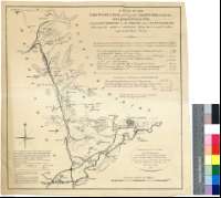
Título: A Plan of the Erewash Canal, part of the Cromford canal and a proposed Canal from Langley Bridge to the Trent near Nottingham [Material cartográfico] ; shewing the relative situation they bear to each other and to the River Trent
Outros títulos: Título distintivo: A plan of a new Intended Canal From the Mouth of the Derwent River and the Grand Trunk Canal, cross the Ereswash Canal and Erewash River sjirting the lower parts of Nottingham and terminating below all the Shoals next adjoining, to, and below Trent Bridge
Área de datos: Escala [ca. 1:64400]
Publicación: [United Kingdom] : [s. n.], [17??]
Descrición física: 1 map. : col. ; 41 x 39 cm
Apuntamentos: Escala gráfica de 4 millas [= 10 cm]. Orientado con lis en ros de ocho vientos
Orografía a trazos
El canal proyectado, cercano a la ciudad de Nottingham, aparece resaltado en color amarillo
Figuran vrias tablas, con datos referentes a las distancias entre los distintos tramos de los canales
Forma parte de la Colección Mendoza
Materia / lugar / evento: Canal de Erewash - S. XVIII - Mapas
Inglaterra - Canales - Mapas
Inglaterra - S. XVIII - Mapas
Nome xerárquico de lugar: Gran Bretaña - Inglaterra
Títulos secundarios: EREWASH (Reino Unido) (Inglaterra). Canales. 1:64400 (17)
CDU: 912:626.13(083.9)(420)"17"
420 Erewash, Canal
Tipo de publicación:
 Mapas
Mapas
Derechos: