
Bowles's Draught of the River Thames, from it's Spring in...


Sección: Mapas
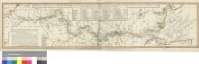
Título: Bowles's Draught of the River Thames, from it's Spring in Gloucester-shire, to it's Influx into the Sea : with a Table of all the Locks, Wears, and Bridges thereupon, Shewing the Tolls Payable at each and their distance by Water from one another [Mapa] / J. Ellis sculpt
Edición: Corr. 1793
Área de datos: Escala [ca. 1:320000]
Publicación: London : Published as the Act direts... Printed for Carrington Bowles, at his Map & Print Warehouse, No. 69 in St. Pauls Church Yard,..., 1793
Descrición física: 1 map. : col. ; 20 x 89 cm
Apuntamentos: Fecha de publicación más antigua de las que aparecen en el documento: "1st. Jan. 1774"
Escala hallada a partir de 10 minutos de latitud [= 5,8 cm]. Coordenadas referidas al meridiano de Londres (O 2°20'--E 1°40'/N 51°53'--N 51°20'). Red geográfica de 10' en 10'. Orientado con lis en rosa de ocho vientos inscrita en círculo
Orografía a trazos. Sondas batimétricas y bancos
Líneas divisiorias de los condados por los que discurre el río diferenciadas por colores
Tabla de signos para indicar las presas y puentes del río, y clave alfabética para determinar sus rápidos, desde Londres hasta su desembocura
Breve leyenda descriptiva del curso del río
Señala la distancia entre lugares con derecho a molienda
Forma parte de la Colección Mendoza
Materia / lugar / evento: Mapas generales
Ríos
Divisiones administrativas
Batimetría
Inglaterra
Otros autores: Bowles, Carrington
Ellis, John, fl. 1766-1796
Títulos secundarios: TAMESIS (Río). Mapas hidrográficos. 1:320000 (1793)
CDU: 912:556.53:551.46+(1-35)(420)(282.242)"1793"
282.242
420
Tipo de publicación:
 Mapas
Mapas
Derechos: