
A new map of England & Wales


Sección: Mapas
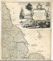
Título: A new map of England & Wales [Mapa] / Drawn from several Surveys &c. on the New Projection Corrected from Astronomical Observations, & the Places marked where the Observations were made By Thos. Kitchin Geogr. ; The Canal's inserted to 1792, by Philips, Surveyer
Autor: Kitchin, Thomas, 1718-1784
Área de datos: Escala [ca. 1:568000]
Publicación: London : Publish'd by Laurie & Whittle N° 53, Fleet Street, as the Act directs, 12th. May 1794
Publicación, Producción, Distribución, etc.: Fabricación: London : Printed for Robt. Sayer, Print-Seller, as the Act directs, 12th Novr. 1792
Descrición física: 1 map. en 4 h. : col. ; 128 x 108 cm en h. de 67 x 56 cm
Apuntamentos: Escala gráfica de 30 millas estatutarias [= 8'5 cm]. Coordenadas referidas al meridiano de Londres (O 7°02'--E 1°43'/N 55°56'--N 49°26'). Red geográfica de 1° en 1°. Orientado con lis en rosa de ocho vientos. Mención nominal de puntos cardinales
Orografía de perfil. Veriles de sonda y bajos
Constan dos tablas, una para señalan los cursos navegables de Inglaterra y Gales y otra de signos convencionales, para indicar la categoria de los núcleos de población
Relación de las divisiones administrativas identificadas por clave cromática
Título, autor y editor enmarcados en cartela rococó, acompañada de una escena portuaria
Inserta : "The Isles of Scilly : are inserted here to the same Scale". Coordenadas referidas al meridiano de Londres (O 7°22'--O 6°12'/N 50°08'--N 49°49')
Materia / lugar / evento: Mapas generales
Navegación fluvial
Divisiones administrativas
Gales
Otros autores: Phillips, John, fl. 1792
Sayer, Robert, 1725-1794
Kitchin, Thomas, 1718-1784
Laurie and Whittle (Londres)
Títulos secundarios: INGLATERRA (Reino Unido). Mapas generales. 1794. 1:568000 (1792)
CDU: 912:629.123(1-35)(420)(429)"1792"
420
429
Tipo de publicación:
 Mapas
Mapas
Derechos: