
A Map of Pennsylvania : Exhibiting not only the Improved...


Sección: Mapas
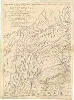
Título: A Map of Pennsylvania : Exhibiting not only the Improved Parts of that Province, but also its Extensive Frontiers..
Área de datos: Escala [ca. 1:370000], 30 english miles [= 13 cm]
Publicación: London : Robert Sayer and J. Bennett, 1775
Descrición física: 1 mapa en 3 h. : col. ; h. de 69 x 36 cm ó menos
Apuntamentos: Bajo el título: "To the Honourable Thomas Penn and Richard Penn Esquires..."
Coordenadas referidas al meridiano de Londres (O 79º46'-O 74º20'/N 41º48'-N 39º37')
Relieve representado por sombreado
Coloreado a la acuarela en rojo, verde y amarillo
Materia / lugar / evento: Mapas generales
Orografía
Cuencas hidrográficas
Otros autores: Sayer and Bennett (Londres)
Títulos secundarios: PENSILVANIA (Estados Unidos). Mapas generales. 1:370000 (1775)
CDU: 748
Tipo de publicación:
 Mapas
Mapas
Derechos: