
Bowles's New Pocket Map of the County of Bedford, divided...


Sección: Mapas
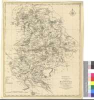
Título: Bowles's New Pocket Map of the County of Bedford, divided into its Hundreds with the Roads and Distances in measured Miles [Mapa]
Área de datos: Escala [ca. 1:90000]
Publicación: London : Printed for the Proprietor Carington Bowles, No.69 in St. Pauls Church Yard, 1764-1793
Descrición física: 1 map : col ; 53 x 43 cm
Apuntamentos: Fecha de publicación deducida de la actividad editora de Carington Bowles
Escala gráfica de 7 millas estatutarias inglesas de 69 1/2 al grado [= 12,5 cm]. Coordenadas referidas al meridiano de Londres (O 0°38'20'--O 0°01'30''/n 52°27'30''--N 51°59'40''). Red geográfica de 5' en 5'. Orientado con lis en rosa de ocho vientos
Orografía a trazos
Líneas divisorias entre los hundreds clave que conforman el condado, diferenciadas por color
Señala la distancia en millas entre los distintos tramos de las carreteras, indicando además lo que hay entre las poblaciones y Londres
Tabla de signos convencionales para indicar distintos tipos de poblaciones y accidentes geográficos
Forma parte de la Colección Mendoza
Materia / lugar / evento: Mapas generales
Divisiones administrativas
S.XVIII
Inglaterra
Otros autores: Bowles, Carrington
Títulos secundarios: BEDFORDSHIRE (Reino Unido) (Inglaterra). Mapas generales. 1:90000 (1764-1793?)
CDU: 912:528.021(1-37)(420)"1764/1793"
420 Bedfordshire, Condado
Tipo de publicación:
 Mapas
Mapas
Derechos: