
Cary's New Pocket Plan of London, Westminster and...


Sección: Mapas
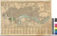
Título: Cary's New Pocket Plan of London, Westminster and Southwarck : With all the adjacent Buildings in St. George's Fields &c. &c. to whitch are annexed (form Authority) the exact Boundary of the Rules of the King's Bench Prison, the situation of the Receiving Houses of the General & Penny Post offices : References to the Public Building &c. also a Correct list of upwards of 350 Hackney Coach Fares [Mapa]
Área de datos: Escala [ca. 1:16100]
Publicación: London : Printed for J. Cary, Engraver, Map & Printseller, N° 181, Strand, Jany. 1, 1794
Descrición física: 1 plan. : col. ; 41 x 60 cm
Apuntamentos: Escala gráfica de media milla estatutaria [= 5 cm]
Orografía por nomales
Inserta e incluye tablas con las direcciones de las oficinas de correos y casas de alquiler de coches
Clave cromática para indicar las límites de la ciudad de Londres y "King Bench Prisión"
Materia / lugar / evento: Planos de población
Divisiones administrativas
Correos
Gran Londres
Inglaterra
Otros autores: Cary, John, ca. 1754-1835
Títulos secundarios: LONDRES (Reino Unido). Planos de población. 1:16100 (1794)
CDU: 912:314(084.3)]+656.8(1-21)(421)"1794"
421
Tipo de publicación:
 Mapas
Mapas
Derechos: