
Map of the world showing the distribution and limits of...


Sección: Mapas
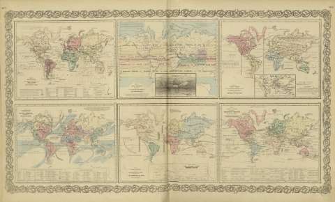
Título: Map of the world showing the distribution and limits of cultivation of the principal plants : useful to mankind / [drawn by George Woolworth Colton]
Área de datos: Escala indeterminada (O 180º--E 180º /N 80º-- S 70º)
Publicación: New York : published by G.W. and C.B. Colton & co., [1872]
Descrición física: 1 mapa : col. ; 17 x 22 cm
Apuntamentos: Inserta: Chart showing the vertical range of various plants.
Con: Map of the world illustrating the principal features of the land and the co - tidal lines ; Map of the world showing the principal ocean currents & boundaries of river systems ; Map of the world illustrating the principal features of meteorology ; Map of the world showing the geographical distribution & range of the principal members of the animal kingdom ; Map of the world illustrating the productive Industry of various countries & exhibiting the principal features of commerce and navigation.
rexistros relacionados: En: Colton's General Atlas : containing one hundred and eighty steel plate maps and plans, on one hundred and nineteen imperial folio sheets. - New York : published by G.W. and C.B. Colton & Co. n 172 William St., [1872]. - Nº 7 - 8
Materia / lugar / evento: Fitogeografía
Cultivos
Agricultura
Mundo - Mapas
Otros autores: G.W. & C.B. Colton & Co.
Títulos secundarios: Mundo. Vegetación (1872)
CDU: 912:581.9]:[631.5+63](100)'1872'
100
Tipo de publicación:
 Mapas
Mapas
Derechos: