
Colton's England and Wales


Sección: Mapas
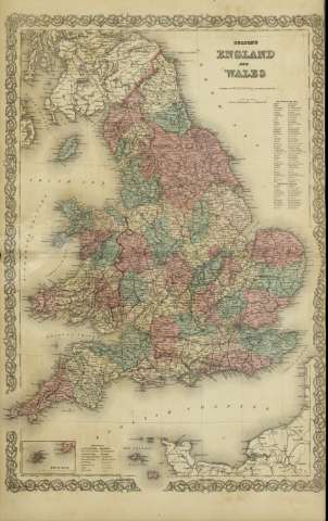
Título: Colton's England and Wales / [drawn by George Woolworth Colton]
Área de datos: Escala [ca. 1:1.511.714], 40 miles [= 4,9 cm] (O 00º--E 2º /N 56º00'--N 49º10')
Publicación: New York : published by G.W. and C.B. Colton & Co., [1872]
Descrición física: 1 mapa : col. ; 70 x 44 cm, pleg. en 44 x 36 cm
Apuntamentos: Indica meridianos de origen: Washington y Greenwich ; Márgenes graduados.
Indica divisiones administrativas marcadas por colores.
Incluye clave de signos indicando red de carreteras, ferrocarriles, canales y ciudades.
Inserta: Scilly Isles.
Inserta nota: "Entered according to Act of Congress in the year 1855 by J.H. Colton & Co. in the Clerk's office of the district court for the southern district of New York".
rexistros relacionados: En: Colton's General Atlas : containing one hundred and eighty steel plate maps and plans, on one hundred and nineteen imperial folio sheets. - New York : published by G.W. and C.B. Colton & Co. n 172 William St., [1872]. - Nº 95 - 96
Materia / lugar / evento: Mapas políticos
Divisiones administrativas - Mapas
Gales - Mapas
Inglaterra - Mapas
Nome xerárquico de lugar: Gran Bretaña - Inglaterra
Gran Bretaña - Gales
Otros autores: G.W. & C.B. Colton & Co.
Títulos secundarios: REINO UNIDO. Divisiones administrativas. 1:1511714 (1872)
CDU: 912:[625.1+625.7](410 Gran Bretaña)'1872'
410 Gran Bretaña
Tipo de publicación:
 Mapas
Mapas
Derechos: