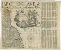
England & Wales fully described with the Roads, Distances...
Sección: Mapas
Título: England & Wales fully described with the Roads, Distances of Measured & Computed Miles, Market Days, and Towns that send Members to Parliament & c. [Mapa]
Área de datos: Escala [ca. 1:710000]
Publicación: London : Printed for Robt. Sayer Map & Print Seller at the Golden Buch in Fleet Street, [1751-1794?]
Descrición física: 1 map. en 4 h. : col. ; 98 x 117 cm, en h de 52 x 63 cm
Apuntamentos: En el margen superior aparece otro título más abreviado
Se ha tomado este intervalo en la fecha de edición por ser este el período durante el que trabajó como editor Robert Sayer
Escala hallada a partir de un grado de latitud [= 15,6 cm]. Coordenadas referidas al meridiano de Londres (O 6°20'--E 2°20'/N 55°50'--N 50°05'). Red geográfica de 10' en 10' en latitud y de 20' en 20' en longitud. Orientado con lis en rosa de treinta y dos vientos, con mención nominal de cada uno de ellos
Señala con diferente color las líneas divisorias entre los condados
Leyenda en la que se incluye una tabla de signos convencionales para indicar los distintos tipos de población y carreteras con datos relativos a las observaciones astronómicas realizadas y en la que se da información sobre las tablas que aparecen en los márgenes laterales
Estas tablas ordenan alfabéticamente todas las poblaciones que aparecen en el mapa, aportando datos sobre su ubicación por medio de letras y números, distancia desde Londres, día de la semana que tiene mercado y número de representantes en el Parlamento
Mención de venta de éste y de otros mapas que se pueden encontrar en la misma tienda
Dos cartelas barrocas, una enmarcando el título y el pie de imprenta decorrada con motivos mitológicos y escudo de la casa real inglesa y otra con la leyenda, decorada con motivos vegetales y el mismo escudo
Forma parte de la Colección Mendoza
Materia / lugar / evento: Mapas generales
Carreteras
Divisiones administrativas
Núcleos de población
S.XVIII
Gales
Otros autores: Sayer, Robert, 1725-1794
Títulos secundarios: INGLATERRA (Reino Unido). Mapas generales. 1:710000 (1751-1794?)
CDU: 912:314:625.7:528.021:(1-35)(420)(429)"1751/1794"
420
429
Tipo de publicación:
![]() Mapas
Mapas
Derechos: CC BY. Esta licencia permite utilizar las obras siempre que se mencione la fuente de procedencia
© Ministerio de Cultura


