
A Map of the Countries Thirty Miles Round London


Sección: Mapas
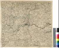
Título: A Map of the Countries Thirty Miles Round London [Mapa] / Drawn & Engraved from Accurate Surveys by Thos. Kitchin Geogr. Engraver, Hidrographer to his Majesty
Autor: Kitchin, Thomas, 1718-1784
Área de datos: Escala [ca. 1:191500]
Publicación: London : printed for T. Kitchin... : Robt. Sayer... : Carington Bowles... : H. Parker..., [17--?]
Descrición física: 1 map. : col. ; 47 x 53 cm
Apuntamentos: Comprende la parte suroriental de Inglaterra con parte de los condados de Essex, Hertfordshire, Buckingham, Berkshire, Surrey, Kent y el antiguo condado de Middlesex, actualmente absorbido en el de Gran Londres
Escala gráfica de 5 millas estatutarias británicas de 69 al grado [= 4,2 cm]. Coordenadas referidas al meridiano de Londres (O 0°44'--E 0°45'/N 52°56'--N 51°09')
Orografía de perfil
Tabla de signos convencionales para indicar ciudades y pueblos, caminos cerrados y abiertos, casas nobles y rurales, parques, iglesias etc.
Límites entre los condados diferenciados por color
Materia / lugar / evento: Mapas generales
Divisiones administrativas
Otros autores: Sayer, Robert, 1725-1794
Bowles, Carrington
Parker, Henry
Títulos secundarios: INGLATERRA (Reino Unido). SE. Mapas generales. 1:191500 (17)
CDU: 912:(1-35)(420-12)"17"
420-12
Tipo de publicación:
 Mapas
Mapas
Derechos: