
Scandia or Scandinavia Comprehending Sweden, and Norway,...


Section: Maps
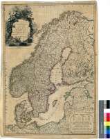
Title: Scandia or Scandinavia Comprehending Sweden, and Norway, withn the Danish Islands [Material cartográfico] : to which is added the remainder of the Possesions of Denmark / By L.S. Delarochette ; Wm. Palmer sculp
Área de datos: Escala [ca. 1:3150000]
Publication: London : Published by Wm. Faden, Geographer to the King, and to His R.H. the Prince of Wales, February 10th. 1794
Physical description: 1 map. : col. ; 70 x 49 cm
Notes: Comprende Suecia, Noruega, Finlandia, Dinamarca, las costas de Alemania y Polonia y una pequeña parte de la zona noroccidental de la URSS
Escalas gráficas de 180 millas estatutarias inglesas de 69 1/2 al grado [= 9,2 cm], 35 leguas suecas de 12 1/2 al grado, 60 leguas suecas de 21 al grado, 30 leguas danesas comunes de 13 1/2 al grado, 30 leguas noruegas comunes de 10 al grado, y 300 verstas rusas de 104 1/2 al grado. Coordenads referidas al meridiano de Londres (O 3°--E 37°/N 72°--N 53°). Red geográfica de 1° en 1° para la longitud y de 2° en 2° para la latitud
Orografía de perfil
Fronteras y límites de las distintas divisiones de los territorios representados diferenciados por color
Leyenda explicativa sobre los accidentes geográficos más significativos
Título y escalas enmarcadas en cartelas, decorada la primera con un paisaje
Forma parte de la Colección Mendoza
Materia / lugar / evento: Mapas generales
Divisiones administrativas
Escandinava, Península - S. XVIII - Mapas
Otros autores: Faden, William, 1750-1836
Palmer, William
Títulos secundarios: EUROPA. N. Mapas generales. 1:3150000 (1794)
UDC: 912:(1-2/-5)(4-17)"1794"
4-17
Type of publication:
 Maps
Maps
Derechos: