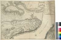
Plan of the City and Environs of Quebec : with its siege...


-
Sail: Planos
Izenburua: Plan of the City and Environs of Quebec [Material cartográfico] : with its siege and blockade by the americans, from the 8th. of December 1775 to the 13th. of May 1776 / Engraved by Wm. Faden
Autorea: Faden, William, 1750-1836
Datu-area: Escala [ca. 1:7000]
Argitalpena: London : Published as the Act directs... by Wm. Faden (Succesor to the Late Mr. Thos. Jefferys) Corner of St. Martin's Lane, 12 Septmr. 1776
Deskribapen fisikoa: 1 plano ; 45 x 62 cm
Oharrak: Escala gráfica de 600 yardas [= 7,8 cm]. Orientado con media lis en rosa de 8 vientos
Relación de los baluartes y edificios más significativos de la ciudad, indicados por clave alfabética
Señala el plan de fuego de las baterías americanas sobre la plaza de Québec
Procede de la "Colección Mendoza"Materia / lugar / evento: Quebec - S. XVIII - Mapas
Canadá - Historia - 1775-1776
Estados Unidos - Historia - Revolución, 1775-1783 Tokiaren izen hierarkikoa: Canadá - Quebec
Bigarren mailako izenburuak: QUÉBEC (Canadá). Operaciones bélicas. 1:7000 (1775 (1776)
CDU: 714 Québec
Argitalpen mota:
 Mapak
Mapak
Derechos:
Otros temas relacionados: S. XVIII Mapas Quebec Historia 1775-1776 Canadá Revolución, 1775-1783 Estados Unidos Ontzi MuseoaSignatura: MN 142-9