
A Plan of the Intended Navigable Canal, from the...


Sail: Planos
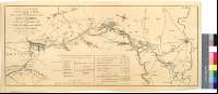
Izenburua: A Plan of the Intended Navigable Canal, from the Worcester & Birmingham Canal at Kings Norton, in the County of Worcester ; to Stratford upon Avon, in the County of Warwick [Material cartográfico] ; also the collateral Branches to Grafton &c / surveyed by John Snape
Autorea: Snape, John, fl. ca. 1781-1792
Datu-area: Escala [ca. 1:48400]
Argitalpena: [s. l.] : [s. n.], 1792
Deskribapen fisikoa: 1 map. ; 29 x 70 cm
Oharrak: Comprende parte de los condados ingleses de Warwickshire y Midlands del Oeste
Escala gráfica de 4 millas, divididas en estadios [= 13,3 cm]. Orientado con lis en rosa de ocho vientos
Orografía a trazos
Relación de las principales parroquias que jalonan el recorrido del canal, indicadas por clave numérica
Figura una tabla con datos referentes a la longitud y caída de los distintos tramos de la obra proyectada
Forma parte de la Colección Mendoza
Materia / lugar / evento: Inglaterra - S. XVIII - Mapas
Inglaterra - Canales - Mapas
Worcestershire - Canales - S. XVIII - Mapas
Warwickshire - Canales - S. XVIII - Mapas
Tokiaren izen hierarkikoa: Gran Bretaña - Inglaterra
Bigarren mailako izenburuak: WARWICKSHIRE (Reino Unido) (Inglaterra). Canales. 1792?. 1:48400
CDU: 912:626.13(083.9)(420-37)"1792"
420 Warwickshire, condado
420 Midlands del Oeste, condado
Argitalpen mota:
 Mapak
Mapak
Derechos: