
Plan of the Proposed Crinan Canal betwen the Lochs of...


Sail: Planos
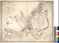
Izenburua: Plan of the Proposed Crinan Canal [Material cartográfico]betwen the Lochs of Crinan and Gilp, in the county of Argyll / Surveyed at the expence of His Grace the Duke of Areggyll and the Earl of Brecadalbane in the Year 1792, By John Rennie Engineer
Autorea: Rennie, John, (1761-1821
Datu-area: Escala [ca. 1:21800]
Argitalpena: [London] : Engraved by W. Faden, Geogr. to the King & To His R.H. the Prince of Wales, Charing Cross, 1792
Deskribapen fisikoa: 1 mapa : col. ; 51 x 65 cm
Oharrak: Comprende parte de la región escocesa de Strathclyde
Escala gráfica de 8 estadios ó 1 milla [= 7,4 cm]. Orientado con lis en rosa de ocho vientos
Relieve representado a trazos
Señala el canal de Crinan en color rojo
Figuran dos tablas referentes a las dimensiones y capacidad de los tramos de la obra proyectada
Forma parte de la Colección Mendoza
Materia / lugar / evento: Canal de Crinan - S. XVIII - Proyectos
Argyll y Bute - Canales - S. XVIII - Mapas
Escocia - S. XVIII - Mapas
Escocia - Canales - Mapas
Tokiaren izen hierarkikoa: Gran Bretaña - Escocia
Otros autores: Faden, William, 1750-1836
Bigarren mailako izenburuak: CRINAN (Reino Unido) (Escocia) (Canal). Cables submarinos. 1:21800 (1792?)
CDU: 912:626.13(083.9)](411)"1792"
411 Crinan, canal
411 Strathclyde, región
Argitalpen mota:
 Mapak
Mapak
Derechos: