
The County Palatine of Chester : reduced from the large...


Sail: Mapak
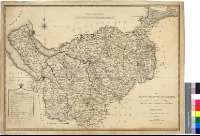
Izenburua: The County Palatine of Chester [Material cartográfico] : reduced from the large Survey, in four sheets / by P. P. Burdett ; Copied and Engraved by James Stuart, Chester
Autorea: Burdett, Peter P., fl. 1786-1794
Datu-area: Escala [ca. 1:136000]
Argitalpena: London : Published by W. Faden, Geogr. to His Majesty and to H.R.H. the Prince of Wales, Charing Cross, Septr, 1st. 1794
Deskribapen fisikoa: 1 map. : col. ; 49 x 69 cm
Oharrak: Escala gráfica de 12 millas estatutarias [= 14,2 cm]. Coordenadas referidas al meridiano de Londres (O 3°25'--O 1°39°/N 53°36'--N 53°00'). Recuadro geográfico de 5' en 5'. Figura trazado el meridiano de Chester. Orientado
Orografía a trazos
Tabla de signos convencionales para indicar las ciudades, parroquias, lagos, molinos, caminos, límites entre "hundreds", etc.
Forma parte de la Colección Mendoza
Materia / lugar / evento: Cheshire - S. XVIII - Mapas
Inglaterra - S. XVIII - Mapas
Género / forma: Mapas administrativos
Tokiaren izen hierarkikoa: Gran Bretaña - Inglaterra
Otros autores: Stuart, James
Faden, William, 1750-1836
Bigarren mailako izenburuak: CHESHIRE (Reino Unido) (Inglaterra). Mapas generales. 1:136000 (1794)
CDU: 912(420-37)"1794"
420 Cheshire, condado
Argitalpen mota:
 Mapak
Mapak
Derechos: