
Cary's New and Accurate Plan of the London and...


Sail: Mapak
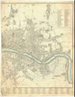
Izenburua: Cary's New and Accurate Plan of the London and Westminster : the Borough of Southwark and parts adjacent : viz. Kensington, Chelsea, Islington, Hackney, Walworth, Newington, &c. with an Alphabetical list of upwards of 500 of the most principal streets with referencens of the their situation [Mapa]
Datu-area: Escala [ca. 1:9900]
Argitalpena: London : Printed for the In°. Cary, Map & Print.Seller, N° 188, Corner of Arundel Street, Strand, Jany. 1 1792
Deskribapen fisikoa: 1 plan. en 2 h. : col. ; 79 x 122 cm, en h. de 82 x 63 cm
Oharrak: Escala gráfica de media milla [= 8'2 cm]. Orientado con lis en rosa de ocho vientos
Orografía por normales
Relación de los principales edificios públicos e iglesias indicadas por clave numérica
Red de cuadrículas para facilitar la localización de las principales calles de la ciudad
Materia / lugar / evento: Planos de población
Mapas generales
Edificios
Edificios religiosos
Gran Londres
Inglaterra
Otros autores: Cary, John, ca. 1754-1835
Bigarren mailako izenburuak: LONDRES (Reino Unido). Mapas generales. 1:9900 (1792)
CDU: 912:314(0'84.3)]:725.1:726(421)"1792"
421
Argitalpen mota:
 Mapak
Mapak
Derechos: