
Central American and West Indian ports


Sail: Mapak
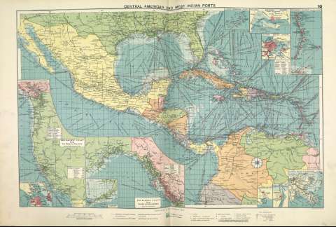
Izenburua: Central American and West Indian ports [Material cartográfico]
Autorea: Philip, George
Datu-area: 1:10.000.000
Argitalpena: [London] ; [Liverpool] : George Philip & Son, Ltd : The London Geographical Institute : Philip, Son & Nephew, [1922]
Deskribapen fisikoa: 1 mapa ; 49 x 72 cm
Oharrak: Copia digital. Madrid : Ministerio de Cultura. Dirección General del Libro, Archivos y Bibliotecas, 2010
Inserta mapas de: San Francisco ; Salina Cruz ; Puerto Mexico ; Mouths of the Mississippi ; Bermudas ; Kingston ; Havana ; Windward Islands ; The Pacific coast from San Diego to Vancouver ; The Pacific coast from Seattle to Dutch Harbor
Erregistro erlazionatuak: En: Philip's Mercantile Marine Atlas. - [London] : Edited by George Philip [et al.], 1922. - Mapa 24
Registros incluidos: Philip's Mercantile Marine Atlas . - [London] : Edited by George Philip [et al.], 1922
Materia / lugar / evento: Rutas marítimas - Mapas
Puertos
América Central - Mapas
Género / forma: Cartas náuticas
Tokiaren izen hierarkikoa: América central
Otros autores: George Philip & Son Ltd.
Merchant, Shippers, Exported and Ocean Travelles
The London Geographical Institute
Bigarren mailako izenburuak: América Central. Mapas generales. ca. 1922
CDU: (728)
(729)
Argitalpen mota:
 Mapak
Mapak
Derechos: