
Map of the world illustrating the principal features of...


Sail: Mapak
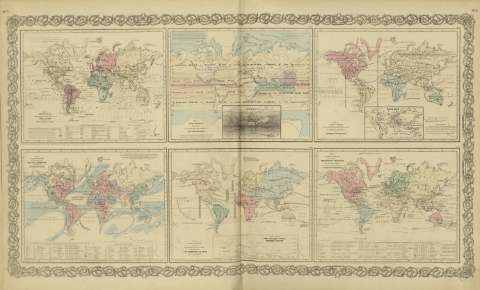
Izenburua: Map of the world illustrating the principal features of the land and the co - tidal lines / [drawn by George Woolworth Colton]
Autorea: Colton, George Woolworth, 1827-1901
Datu-area: Escala indeterminada (O 180º--E 180º /N 80º--S 70º)
Argitalpena: New York : published by G.W. and C.B. Colton & Co., [1872]
Deskribapen fisikoa: 1 mapa : col. ; 17 x 22 cm, en h. de 44 x 36 cm
Oharrak: Incluye leyenda de signos utilizados.
Inserta: List or table lands or plateurs ; Plains or Lowlands.
Con: Map of the world illustrating the principal features of meteorology ; Map of the world showing the geographical distribution & rauge of the principal members of the animal kingdom ; Map of the world showing the principal ocean currents & boundaries of river systems ; Map of the world showing the distribution and limits of cultivation of the principal plants ; Map of the world illustrating the productive industry of various countries & exhibiting the principal features of commerce and navigation.
Erregistro erlazionatuak: En: Map of the world illustrating the principal features of meteorology. - New York : published by G.W. and C.B. Colton & Co., [1872]. - Nº 7 - 8
Materia / lugar / evento: Declinación magnética
Montañas
Fitogeografía
Mareas
Mundo - Mapas
Otros autores: G.W. & C.B. Colton & Co.
Bigarren mailako izenburuak: Mundo. Mapas físicos (1872)
CDU: 912:911.2]:[528.02+551.43+581.9+551.466](100)'1872'
100
Argitalpen mota:
 Mapak
Mapak
Derechos: