
A map of Bengal, Bahar, Oude & Allahabad with part of...


Sail: Mapak
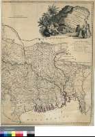
Izenburua: A map of Bengal, Bahar, Oude & Allahabad with part of Agra and Delhi [Material cartográfico] : Exhibiting the Course of the Ganges from Hurdwar to the Sea / By James Rennell, F.R.S. late surveyor Genl. in Bengal
Autorea: Rennell, James
Datu-area: Escala [ca. 1:1550000] (E 77°20'--E 93°15'/N 29°55'--N 20°30')
Argitalpena: London : Printed for Wm. Faden, Geogr. to the king, Charing Cross, Jany. 1st. 1786
Deskribapen fisikoa: 1 map. en 2 h. : col. ; 71 x 106 cm. en h. de 74 x 56 cm
Oharrak: Comprende lo que ocupa actualmente la parte noreste de la India y Bangladesh
Dedicatoria: "To John Stables Esqr. one of the Supreme Council of Bengal. This Map, Engraved from the Original Drawing on the same scale in the Possession of the Honble. East India Company (communicated by him to the late Mr. Dury) is respectfully Inscribed by His obliged and obedient Servant Willm. Faden"
Escala gráfica de 100 millas británicas [= 10'4 cm]. Coordenadas referidas además al meridiano de Calcuta (E 9°00'--E 4°50'). Red geográfica de 2° en 2°. Orientado con media lis
Orografía de perfil
Relación de la división provincial de las posesiones británicas en la península, indicadas por clave cromática
En nota se indican los mapas que se han tomado como referencia para trazar algunas carreteras
Título, autor y editor en cartela con alegoría del Ganges
Materia / lugar / evento: India nororiental - S. XVIII - Mapas
Bangladesh - S. XVIII - Mapas
Ganges (Río) - Mapas
Género / forma: Mapas físicos
Tokiaren izen hierarkikoa: India
Bangladesh
Otros autores: Faden, William, 1750-1836
Bigarren mailako izenburuak: INDOSTAN (Península). NE. Mapas generales. 1:1550000 (1786)
CDU: 912:(1-5)(54-18)"1786"
54-18
Argitalpen mota:
 Mapak
Mapak
Derechos: