
A Plan of the Island of Jersey : with a Sketch of the...


Sail: Planos
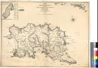
Izenburua: A Plan of the Island of Jersey [Material cartográfico] : with a Sketch of the Batteries Redoubts and Intrenchments Raised along the Coast for the Defende of the Island / By an Officer ; Engraved by Will.m Faden, Geographer to de KING
Argitaraldi: 2d. Edith.
Datu-area: Escala [ca. 1:42000]
Argitalpena: London : Publish'd... by Wm. Faden, Charign cross, Succr. to Mr. Jefferys, Septr. 1 st. 1783
Deskribapen fisikoa: 1 map. : col. ; 59 x 69 cm
Oharrak: Escala gráfica de 3 millas [= 11,5 cm]. Orientado con lis en rosa de ocho vientos
Orografía a trazos
Indica sondas batimétricas, veriles, bajos y bancos de arena
Destaca los límites entre las diversas parroquias
Forma parte de la Colección Mendoza
Inserta : "Plan of Elizabeth Castle". Escala [ca. 1:4200], 600 pies [= 4,4 cm]. Relación de los principales fuertes y baluartes del castillo, indicados por clave alfabética
Materia / lugar / evento: Jersey - Divisiones territoriales - S. XVIII - Mapas
Género / forma: Mapas administrativos
Tokiaren izen hierarkikoa: Gran Bretaña Jersey
Otros autores: Faden, William, 1750-1836
Bigarren mailako izenburuak: JERSEY (Reino Unido) (Isla). Mapas generales. 1:42000 (1783)
CDU: 912:623.1(410:22-28)"1783"
410:32 Jersey
Argitalpen mota:
 Mapak
Mapak
Derechos: