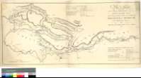
Plan of a Canal from the Town of Brecknock to join the...
Sail: Planos
Izenburua: Plan of a Canal from the Town of Brecknock to join the Monmouth Shire Canal near the Town of Ponty Pool in the Counties of Brecknock and Monmouth [Material cartográfico]: with a Plan of the Monmouth Shire Canal as taken in 1792 / By T. Dadford Junr. Engineer
Autorea: Dadford, Thomas , Junior
Datu-area: Escala [ca. 1:65000]
Argitalpena: [London] : Engraved by W. Faden, Charing Cross, 1793
Deskribapen fisikoa: 1 map. ; 37 x 82 cm
Oharrak: Comprende parte de los condados galeses de Gwent y Powys
Escala gráfica de 4 millas [= 9,9 cm]. Orientado con lis en cuadrante
Orografía a trazos
Figuran dos tablas con datos sobre las dimensiones y capacidad de los tramos en que se dividen los canales de Monmoutshire y Brecon-Abergavenny
Forma parte de la Colección Mendoza
Materia / lugar / evento: Powys - Canales - S. XVIII - Mapas
Gales - Canales - Mapas
Gales - S. XVIII - Mapas
Usk (Gran Bretaña, Río)
Canal de Monmouthshire y Brecon
Tokiaren izen hierarkikoa: Gran Bretaña - Gales
Otros autores: Faden, William, 1750-1836
Bigarren mailako izenburuak: GWENT (Reino Unido) (Gales). Canales. 1:65000 (1793)
CDU: 912:626.13(429)"1793"
429 Gwent, Condado
429 Powys, Condado
Argitalpen mota:
![]() Mapak
Mapak
Derechos: CC BY. Esta licencia permite utilizar las obras siempre que se mencione la fuente de procedencia
© Kultur Ministerioa


