
Bowles's New four-sheet Map of Englands and Wales,...


Sail: Mapak
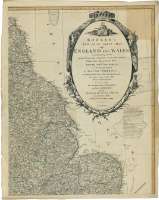
Izenburua: Bowles's New four-sheet Map of Englands and Wales, Comprehending all Cities, Boroughs, Market and Sea Port Towns, Villages, Lakes, Rivers, Forest, Ruins and Principal Seats of the Nobility, with the Roads, described by Daniel Paterson The Distance of each Place of Note from the Metropolis, and a great variety of another useful Modern Improvements : To which is added The South Part of Scotland, and East of Ireland, with the Maritime Provinces of France, from Dunkirk of Grest, and Inland Country to Paris [Mapa]
Argitaraldi: Corr. 1794
Datu-area: Escala [ca. 1:660000]
Argitalpena: London : Printed for the Propietors Bowles & Carver, No. 69 St. Pauls Church Yard, Publish'd as the Act directs, 1794
Deskribapen fisikoa: 1 map. en 4 h. : col. ; 129 x 101 cm, en h. de 68 x 54 cm
Oharrak: Fecha de publicación más antigua de las que aparecen en el documento: "2 Jan. 1782"
Escala gráfica de 40 millas estatutarias inglesas de 69 1/2 al grado [= 9,8 cm]. Coordenadas referidas al meridiano de Londres (O 7°18'--E 3°16'/N 56°00'--N 48°20'). Red geográfica de 1° en 1°. Orientado con lis en rosa de dieciseis vientos con mención nominal de los puntos cardinales
Orografía de perfil. Indica bancos y bajos
Límites entre los condados y divisiones administrativas francesas, diferenciadas por color
Representa derrotas indicando sus distancias en leguas de tres millas geo métricas de 20 al grado, entre puertos de las islas y dede estas al continnente
Tabla de signos convencionales para indicar distintos tipos de poblaciones, carreteras y accidentes geográficos más significativos
Mención de otras publicaciones recientes
Título y pie de imprenta enmarcados en cartela decorada con una alegoría de la guerra, motivos vegetales y con las figuras de distitnas razas
Forma parte de la Colección Mendoza
Inserta : Mapa de las Islas Scilly
Materia / lugar / evento: Mapas generales
Divisiones administrativas
Derroteros
Gales
Escocia
Irlanda del Norte (Reino Unido)
Reino Unido
Irlanda
Francia
Otros autores: Bowles and Carver
Bigarren mailako izenburuak: INGLATERRA (Reino Unido). Mapas generales. 1:660000 (1794)
CDU: 912:527.6:(1-35)(420)(429)(411-13)(416-11)(417-13)(44-16)"1794"
420
429
411-13
416-11
417-13
44-16
Argitalpen mota:
 Mapak
Mapak
Derechos: