
England and Wales : Laid down from all the surveys of...


Sail: Mapak
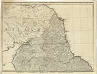
Izenburua: England and Wales : Laid down from all the surveys of Particular Counties hitherto published Distinctly shewing the Cities, Market Towns, & Villages The Roads with the measured Distances thereon according to Mr. Ogilby's Also an accurate delineation of the Sea Coasts and rivers [Mapa] / Laid down by Delarochette & Engraved by Thos. Kitchin
Autorea: Kitchin, Thomas, 1718-1784
Datu-area: Escala [ca. 1:459800]
Argitalpena: London : Printed for Robt. Wilkinson : Carington Bowles... and Robt. Sayer, [177-?]
Deskribapen fisikoa: 1 map. en 12 h. : col. ; 165 x 182 cm en h. de 46 x 60 cm
Oharrak: Comprende además la parte meridional de Escocia y la oriental de Irlanda del Norte e Irlanda
Fecha deducida por comparación con otros documentos existentes en el atlas
Escala gráfica de 24 millas estatutarias de 69 al grado [= 8,4 cm]. Coordenadas referidas al meridiano de Londres (E 8°16'--O 3°20'/N 55°50'--N49°49'). Red geográfica de 20' en 20'. Orientado con lis en rosa de ocho vientos
Orografía por normales
En los márgenes superior e inferior de cada hoja queda reflejado el territorio comprendido en cada una de ellas
Título, mención de responsabilidad y editor contenidos en cartela flanqueada por dos personajes y decorada por un cofre con tesoros y otros objetos. Esta cartela ocupa por sí sola una de las doce hojas que conforman el mapa
Divisiones administrativas diferenciadas por colores
Materia / lugar / evento: Mapas generales
Divisiones administrativas
S.XVIII
Gales
Escocia
Irlanda del Norte (Reino Unido)
Reino Unido
Otros autores: La Rochette, Louis Stanislas D'Arcy de
Wilkinson, Robert, fl. 1785-1825
Bowles, Carrington
Sayer, Robert, 1725-1794
Bigarren mailako izenburuak: INGLATERRA (Reino Unido). Mapas generales. 1:460000 (177)
CDU: 912:(1-35)(420)(429)(411-13)(416-11)(417-11)"177"
420
429
411-13
416-11
417-11
Argitalpen mota:
 Mapak
Mapak
Derechos: