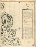
A map of the County of Antrim
Sail: Mapak
Izenburua: A map of the County of Antrim / from actual survey by J. Lendrick 1780 ; Engrav'd by S. Pyle, N°4 Renelagh Street Pimlico, London
Autorea: Lendrick, Jonh
Datu-area: [Ca. 1:66000]
Argitalpena: [London? : s.n.], Jany. 1st. 1782
Deskribapen fisikoa: 1 mapa en 4 h. : col. ; 142 x 107 cm en h. de 76 x 58 cm
Oharrak: Dedicatoria: "To the noblemen, and gentlemen of the County of Antrim, this map, is most respectfully Inscribed, by their much Obliged, Obedient and very humble Servant Lendrick"
Escalas gráficas de 4 millas británicas de 69 1/2 al grado [= 9,7 cm] y 3 millas irlandesas [= 9,3 cm]. Coordenadas referidas al meridiano de Londres (O 6°52'-O 5°46'/N 55°16'-N 54°26'). Red geográfica de 5' en 5'. Orientado con lis en rosa de treinta y dos vientos prolongados, señalando además la variación magnética observada
Relieve representado por normales
Indica sondas batimétricas y veriles
Tabla de signos convencionales para indicar los caminos, ciudades, iglesias, castillos, fondeaderos, dirección de las corrientes marinas, etc.
Destaca los límites entre las parroquias y baronías
Figuran tablas sobre las mansiones de los caballeros, las fincas rústicas, dimensiones de los caminos y datos geográficos en general sobre el condado
Impreso en varios colores
Inserta: "The East Prospect of the Giant's Canseway, in the County of Antrim"
Materia / lugar / evento: Mapas generales
Datos geográficos
Divisiones administrativas
Irlanda del Norte (Reino Unido)
Reino Unido
Otros autores: Pyle, Stephen, fl. S.XVIII-S.XIX
Bigarren mailako izenburuak: ANTRIM (Reino Unido) (Irlanda del Norte). Mapas generales. 1782. 1:66000 (1780)
CDU: 912:91(1-37)(416)"1780"
416 Antrim, condado
Argitalpen mota:
![]() Mapak
Mapak
Derechos: CC BY. Esta licencia permite utilizar las obras siempre que se mencione la fuente de procedencia
© Kultur Ministerioa


