
A Plan of the City and Environs of Philadelphia


Sail: Planos
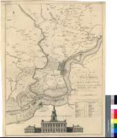
Izenburua: A Plan of the City and Environs of Philadelphia / Survey'd by N. Scull and G. Heap ; Engraved by Willm. Faden. 1777
Autorea: Scull, Nicholas, fl. ca. 1686-ca. 1761
Datu-area: Escala [ca. 1:42300]
Argitalpena: London : Publish'd according to Act or Parlt... by W. Faden Successor to the late Mr.Jefferys Geographer to the King Charing Cross, March 12 th. 1777
Deskribapen fisikoa: 1 mapa ; 62 x 46 cm
Oharrak: Comprende desde la ciudad de German al río Delaware
Escala gráfica de 2 millas [= 7,6 cm]. Orientado con lis en cuadrante
Relieve representado a trazos. Sondas batimétricas
Tabla de distancias en millas y pies, entre algunos lugares y "Court House"
Procede de la "Colección Mendoza"
Incluye: "Elevation of the State House"
Materia / lugar / evento: Mapas generales
Edificios públicos
Perspectivas
Ríos
Planos de población
Pensilvania (Estados Unidos)
Estados Unidos
Otros autores: Heap, George
Faden, William, 1750-1836
Bigarren mailako izenburuak: FILADELFIA (Estados Unidos) (Pensilvania). Mapas generales. 1:42300 (1777)
CDU: 748 Philadelphia
Argitalpen mota:
 Mapak
Mapak
Derechos: