
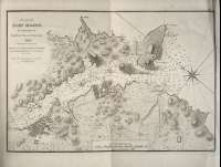
Plan of Port Mahon


Sail: Planos
Izenburua: Plan of Port Mahon [Material cartográfico] / Surveyed by Brigadier Don Vincent Tofiño
Datu-area: Escala ca. 1:16.733. 1 Maritime Mile = 8,3 cm
Argitalpena: London : Published by W. Faden, Geographer to His Majesty, and to His Royal Highness the Prince Regent, 1812
Deskribapen fisikoa: 1 mapa ; 27 x 35 cm
Materia / lugar / evento: Puerto de Mahón - S. XIX
Mahón
Género / forma: Cartas náuticas
Tokiaren izen hierarkikoa: España - Baleares - Mahón
Otros autores: Faden, William, 1750-1836
Dougall, John, 1760-1822, trad.
Bigarren mailako izenburuak: MAHÓN (Baleares) (Menorca) (Puerto). 1:16.733
CDU: 460
Argitalpen mota:
 Mapak
Mapak
Derechos:
Ontzi Museoa
Signatura: MN_A_10022_28