
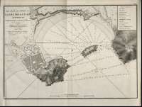
The Bay and Piers of Saint Sebastian


Sail: Mapak
Izenburua: The Bay and Piers of Saint Sebastian [Material cartográfico] / Surveyed by Brigadier Don Vincent Tofino
Datu-area: Escala ^ca. 1:6.313!. 0,5 Maritime Mile ^= 11 cm!
Argitalpena: London : Published by W.Faden, geographer to His Majesty, and to His Royal Highness the Prince Regent, 1812
Deskribapen fisikoa: 1 mapa ; 27 x 35 cm
Materia / lugar / evento: San Sebastián - Muelles - S. XIX
San Sebastián (España, Bahía)
Género / forma: Cartas náuticas
Tokiaren izen hierarkikoa: España - País Vasco - Guipúzcoa - San Sebastián
Otros autores: Faden, William, 1750-1836
Dougall, John, 1760-1822, trad.
Bigarren mailako izenburuak: SAN SEBASTIÁN (Guipúzcoa) (Bahía). 1:6.313
CDU: 460
Argitalpen mota:
 Mapak
Mapak
Derechos: