
The North Sea and the Baltic-cables and wireless stations


Sail: Mapak
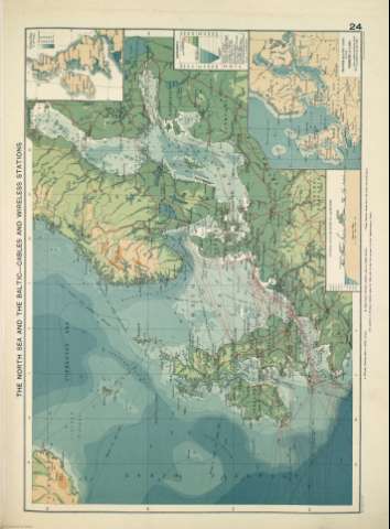
Izenburua: The North Sea and the Baltic-cables and wireless stations [Material cartográfico]
Autorea: Philip, George
Datu-area: 1:12.500.000
Argitalpena: [London] ; [Liverpool] : George Philip & Son, Ltd : The London Geographical Institute : Philip, Son & Nephew, [1922]
Deskribapen fisikoa: 1 mapa ; 36 x 49 cm
Oharrak: Copia digital. Madrid : Ministerio de Cultura. Dirección General del Libro, Archivos y Bibliotecas, 2010
Inserta: the North Sea & the Baltic showing visibility of Land ; A section across the North Sea and the Baltic ; Gran Bretaña
Erregistro erlazionatuak: En: Philip's Mercantile Marine Atlas. - [London] : Edited by George Philip [et al.], 1922. - Mapa 30
Registros incluidos: Philip's Mercantile Marine Atlas . - [London] : Edited by George Philip [et al.], 1922
Materia / lugar / evento: Instalaciones de telecomunicación - Mapas
Mar del Norte - Mapas
Báltico - Mapas
Género / forma: Atlas mundiales
Tokiaren izen hierarkikoa: Mar del Norte
Báltico
Otros autores: George Philip & Son Ltd.
Merchant, Shippers, Exported and Ocean Travelles
The London Geographical Institute
Bigarren mailako izenburuak: Báltico. Mapas generales. ca. 1922
Mar del Norte. Mapas generales. ca. 1922
CDU: (261.26)
(261.24)
Argitalpen mota:
 Mapak
Mapak
Derechos: